
I started this project because my phone just couldn’t perform as a reliable overlanding GPS unit while off-roading. Furthermore, products like the Garmin Tread Overland Edition Navigator make great GPS units specifically tailored to overlanding. Still, these units cost anywhere from $650 to $1400, a price I simply was not willing to commit to. Thus, I created my overlanding GPS unit with a tablet and a GPS receiver.
With very little technical effort, you can also create your own custom GPS unit to fit your needs. I’ll show you how I did it for under $250.
While most people my age are technologically literate, if you’re like me, trying to figure all of this out may seem harder than buying an expensive unit, right? Wrong. On one hand, expensive overlanding GPS modules require a lot of user knowledge to take advantage of the many different features.
On the other hand, I felt more comfortable using my phone since I knew how to use it: I had my GPS apps and could easily download my maps and routes. However, this all took up a lot of storage on my phone, and I found that the GPS location was unreliable, especially in remote locations, causing a lot of missed turns and wasting a lot of time. It was also hard trying to listen to music and get directions on my phone with my overlanding navigation pulled up.
That’s why this DIY unit is undoubtedly the easiest to set up and use at a fraction of the price and hassle of pre-built overlanding GPS systems.
Products Used:
- Samsung Tab A7 Lite: Check Price
- EVO Select + Adapter microSDXC: Check Price
- Garmin GLO 2: Check Price
Table Of Contents
Why Is Good Navigation Important?

Before we cover why accurate navigation is so critical to overlanding, let’s go over the basics of overlanding.
Overlanding is described as self-reliant travel to remote destinations where the journey is the principal goal. Typically, but not exclusively, it is accomplished with mechanized off-road-capable transport (from bicycles to trucks) where the principal form of lodging is camping.
Overlanding is a growing recreational sport, traveling through the vast wilderness of nearly untouched land. As any experienced overlander knows, bad navigation leads to backtracking, U-turns, and getting lost. On one hand, this can lead you to explore further, but often it ends up causing frustration and delaying your travel. After all, the journey is the point of overlanding.
Overlanders need a GPS for accuracy, off-grid capability, route planning, and more. Additionally, when planning a route, you have to mark several points of interest (POIs). These include sleeping arrangements, gas, national and state parks, campsites, etc. The planning process involves estimating the area one can traverse before reaching their desired stop.
Furthermore, if you’re anything like me, overlanding often involves much more than just off-road and camping locations. I like to mark historical sites, fishing ponds, nature sites like waterfalls and mountain peaks, and rock climb and hike.
The same programs you use for overlanding route guidance can also be used to mark and navigate such activities. For example, apps such as Gaia GPS will show you dozens of hiking trails near any location, with most local, state, and national park trails and sites well-mapped.
This can also be useful for recreational off-road parks, whether that be ORV, 4-wheeler, side-by-side, or dirt bike trails. Many off-road parks have online maps created by the park itself or public recordings of trails, which can make a day at the park much easier!
I’ve done this at my local parks, such as Carolina Adventure Worlds and Gulches in SC. I’ve also found tracks for out-of-state trails, such as Bundy Hill in Michigan and the Hayfield and McCoy trails in West Virginia. Furthermore, these digital maps provide helpful information such as road/trail closures, trail difficulties, accidents, etc.
Choosing A Tablet
The main item necessary for this build is a tablet of your choice. When looking for a tablet, I had three main requirements:
- Had to be under $100
- Ample computing power and memory
- Have Bluetooth and a built-in GPS module of some sort that would work without an internet connection
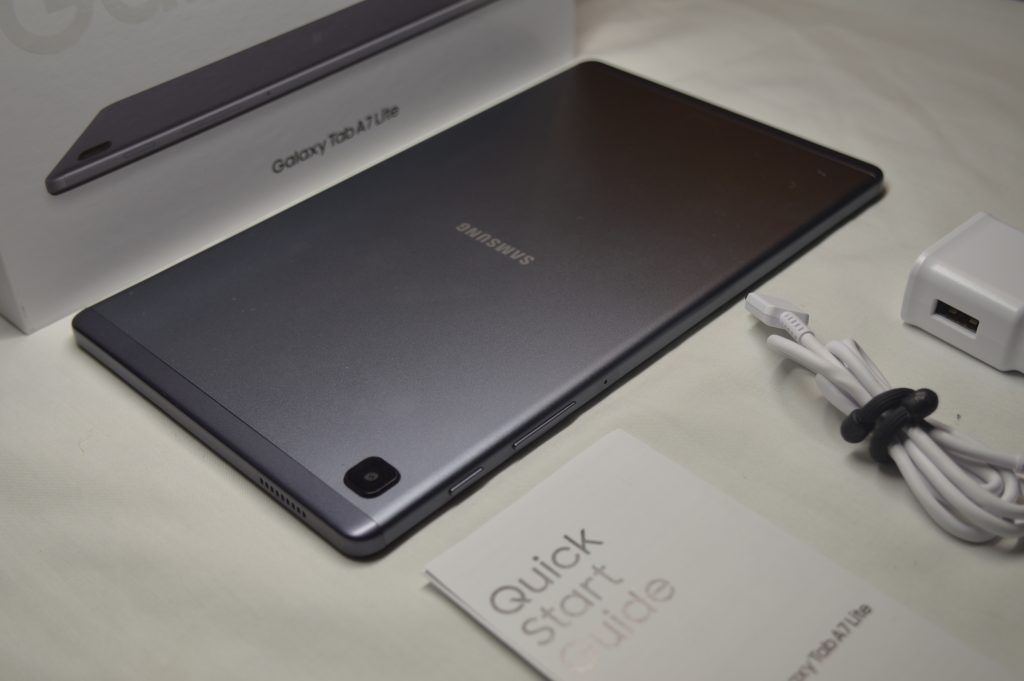
After searching for a tablet that met these requirements, I chose the Samsung Galaxy A7 Lite (the price may be a little higher now). This tablet has an 8.7-inch screen, making it easier to see than a phone without taking up too much space in your rig. It also has ample processing capacity and 2-4GB of RAM for loading your GPS programs.
It comes with 32GB of standard storage, and this tablet allows you to expand the storage with a microSD card up to 1TB. I opted for an additional 256GB microSD to download all the maps, movies, and footage while I’m off the grid.
While I got the Wi-Fi-only version, you can spend more to get an LTE model. However, this setup does not require a SIM card or cellular connectivity. I bought my tablet for $110, a little over my initial budget but a great value.
Note, check the current price above. Another budget-friendly option is to find an “open box” or used listing on eBay.
By no means is this the only option, as you can use pretty much any type of tablet you want. Some other budget options I looked into included tablets from Lenovo and Amazon. I also looked into iPads, but due to the price and lack of expandable storage, I chose an Android tablet.
In addition, I have heard that the GPS module in Apple devices requires either a Wi-Fi or cellular connection to locate via GPS signal; however, I cannot vouch for this from experience.
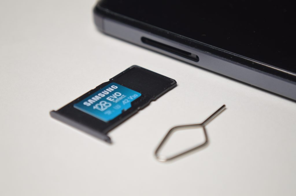
I recommend expanding the Galaxy A7 Lite’s storage with an EVO Select + Adapter microSDXC 128GB, as seen above.
I do not use the A7 as a daily tablet, and I don’t recommend using your overlanding tablet too often outside of your GPS needs. While you certainly can, daily use can use up memory or slow the tablet down. When attempting to navigate via my iPhone, my GPS applications would often crash due to the additional stress of running GPS in parallel with my day-to-day apps.
I also recommend not leaving your device in the vehicle for long periods. Especially when cars get so hot, leaving your device exposed to extreme heat or cold can cause battery damage and further functionality issues. There’s also the theft aspect, especially if you leave your rig parked outside. I also ensure that the tablet’s battery is never under or overcharged, keeping it between 40-80%. These tips should help prolong your tablet’s usable life.
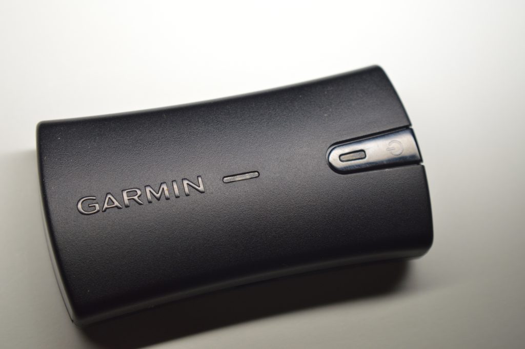
Garmin GLO 2
After acquiring a tablet, the next item on the list is to get an external GPS receiver. This will drastically improve your GPS location accuracy. Receivers improve location accuracy by providing multiple satellite positioning services.
The US Global Positioning System (GPS) is the service we are all familiar with, but did you know there are several mapping satellite systems outside of GPS? Russia’s Global Navigation Satellite System (GLONASS), China’s BeiDou Navigation Satellite System, and the European Union’s Galileo.
Receivers access these additional satellites for improved accuracy. The more satellites it can triangulate off of, the better the location signal you will receive. Furthermore, receivers maintain stronger, more stable satellite connections than your mobile device.
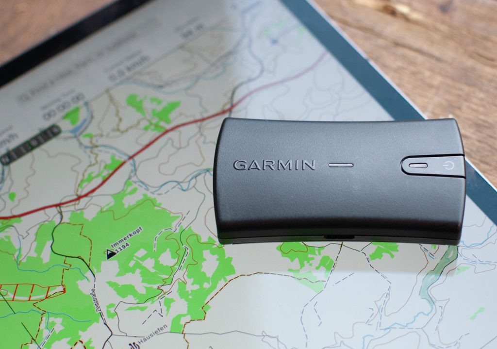
There are few choices when it comes to GPS receivers and mobile devices. The Garmin GLO 2 stands out among others. Garmin has been around recently and has become legendary regarding mapping and navigation.
The “GLO” in the name refers to GLONASS because it can access both GPS and GLONASS satellites. This device connects via Bluetooth and boasts 13 hours of battery life to ensure a strong location without electricity access.
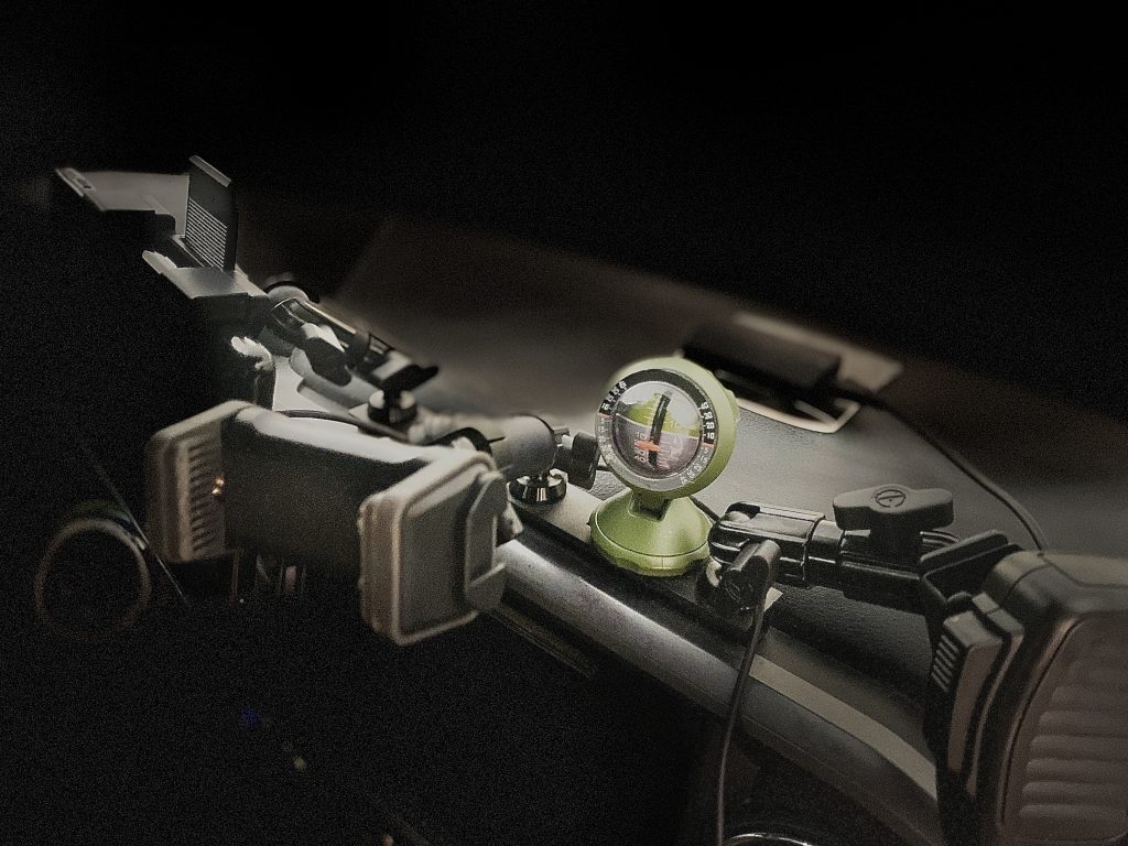
I opted for the dash mount that provides a no-slip dash grip for the GLO 2. Having the unit directly on the dash ensures that the signal has no obstructions, allowing for the best accuracy, up to within 3 yards.
What Programs Can I Run?
So, you’ve got a dependable tablet with accurate GPS signals, what now?
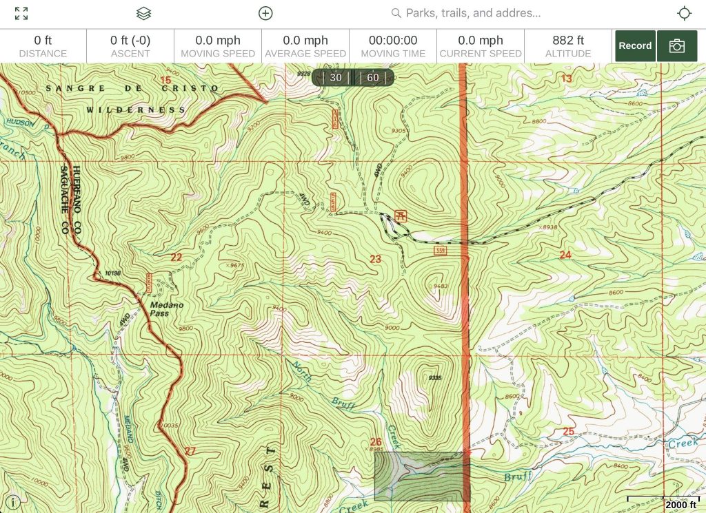
I recommend downloading several GPS applications and programs to see which you like best. To start, the apps I see most commonly used are OsmAnd GPS, Backcountry Navigator, AllTrails, and Gaia GPS. These apps are free but come with in-app purchases. I use all of them for different features and trip planning, but I primarily use OsmAnd.
Garmin has several navigation apps for overlanding, such as Garmin Tread and Garmin Explore. While these apps perform amazingly well, they require a subscription plan. Similarly, OnX off-road is another subscription-based navigation platform that has gained popularity in the community.
So, how do I download trail routes? Simple. Go online and search for available “GPX” files for trails that you’re interested in. Sometimes, these files and trip plans are available for purchase, but often, you can find them free. Most GPX files also come loaded with dozens, if not hundreds, of POIs and alternate routes.
From there, I like to edit the trail to fit my schedule and interests. These apps can be tricky when first starting, so I recommend trying each out and getting familiar with them. While it may require an in-app purchase, most programs will allow you to download maps for offline use.
I find the expandable storage in many Android tablets useful here. I bought a 128GB MicroSD card for $16 and have downloaded all of the US and Mexico. This is also nice for downloading movies when I don’t have a signal on the trail. Furthermore, apps like Dyrt and Free Roam offer public campsites and boundaries.
Other Considerations
While not necessary for your GPS tablet to function, here are some optional accessories to add to your setup.
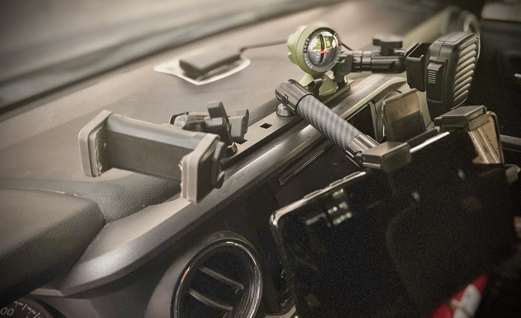
My first recommendation would have to be a dash mount. I have the Taco Bar from Bulletpoint Mounting Solutions, pictured above. While you can customize your options to fit your needs, I have mine set up with their XL phone holder (a great option if you have a bulky phone case like an Otterbox or LifeProof), their tablet holder with a 6” carbon fiber arm, and another adjustable arm for my radio mic.
I also have my Garmin GLO 2 on a nonslip dash mount. Garmin recommends this placement because it allows for optimal satellite signal reception. I can say from experience that a solid mount helped a lot on the trail. Even on harsh bumps, the mount doesn’t move, and the visibility on the trail is impressive.
You should check your local laws to determine the legality of a mounted GPS tablet. Most states allow GPS assistance, but some limit the device type or location, as GPS devices are covered under distracted driving laws.
Distracted driving is no joke, and according to the CDC, it takes 8 lives per day. Never use your GPS tablet while driving for anything but GPS assistance.
While the law specifics vary from state to state, it is illegal in every state to hold any electronic device, including a phone, while operating a motor vehicle. Certain mounts, such as windshield mounts, may also be illegal. These are illegal in over half of the states. Often, these laws may also include stipulations such as the size of the device mounted.
This affects me when I travel through Georgia, as they have stricter laws on GPS use than my home state of South Carolina. Sites such as gpstracklog.com are great sources when researching specific requirements.
I have listed a few of my favorite mounts below. For more options, check out the Best Phone Mounts For 3rd Gen Tacoma Buyer’s Guide.
Another accessory to consider is a tablet case. If you use your tablet while overlanding for other reasons, having a hard protective case is never a bad idea. Companies also make cases with features specifically for GPS tablets.
One such brand is GPSlockbox, which makes lockable mounts and cases to prevent theft if your car is broken into. I also like its unique features such as a radio mic stand and cooling fans.
Another good option is the RAM mounts fan-cooled case. It will inevitably get hot when you run GPS on your tablet for long periods. These fan-cooled cases will prevent heat from building up and protect your tablet’s battery and internals.
Tacoma Dash Mounts To Consider:
- (My Choice:) Bulletpoint Mounting Solutions TacoBar 2016+
- Cali Raised LED Accessory Mount
- Expedition Essentials USB Powered Accessory Mount
- GPS Lockbox: ATMOS Temperature Controlling Cradle Kit
Final Thoughts
After using this setup for the past few weeks, I am very pleased with its performance thus far. The ability to plan routes on the tablet and directly upload .gpx files has made navigation and trip planning a breeze.
The bigger screen is helpful, and I can read the titles of POIs and locations easily. The accuracy of the Garmin GLO 2 has surpassed my expectations, leading to fewer missed turns and inaccurate route guidance.
Overall, this tablet GPS setup performs just as well as many purpose-built overlanding GPS units and is a great option for anyone looking for a great budget navigation system.

Hi Brad,
Thank you for sharing this useful information that is so hard to find on the web. I live in Australia and am working on making this work on Android watch that now has a full version on AllTrails app, working. My questions:
1) Have all the apps mentioned above including AllTrails, worked ok with Glo 2 ?
2) Is it a straight forward setup for android as the watch does have sideloading enabled but it does not have a ‘Mock App’ option available.
Cheers